
Page 90 - Geography_n_Environment
P. 90
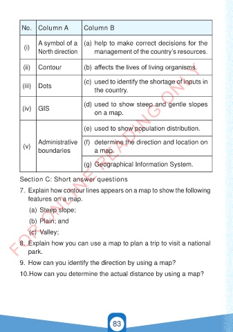
No. Column A               Column B


                 A symbol of a  (a) help to make correct decisions for the
           (i)
                 North direction         management of the country’s resources.

        FOR ONLINE READING ONLY
           (ii)  Contour             (b) affects the lives of living organisms.

                                     (c)  used to identify the shortage of inputs in
           (iii)  Dots
                                         the country.


                                     (d) used to show steep and gentle slopes
           (iv)  GIS
                                         on a map.


                                     (e) used to show population distribution.


                 Administrative  (f)  determine the direction and location on
           (v)
                 boundaries              a map.


                                     (g) Geographical Information System.

          Section C: Short answer questions


          7.  Explain how contour lines appears on a map to show the following
             features on a map.

             (a) Steep slope;

             (b) Plain; and

             (c)  Valley;

          8.  Explain how you can use a map to plan a trip to visit a national
             park.

          9.  How can you identify the direction by using a map?

          10. How can you determine the actual distance by using a map?


                                                 83


                                                                                          21/11/2024   16:59
   GEOGRAPHY AND THE ENVIRONMENT-STD 4.indd   83
   GEOGRAPHY AND THE ENVIRONMENT-STD 4.indd   83                                          21/11/2024   16:59