
Page 10 - Geography_n_Environment
P. 10
FOR ONLINE READING ONLY
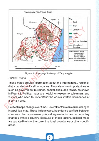
Figure 1: Topographical map of Tanga region
Political maps
These maps provide information about the international, regional,
district and other local boundaries. They also show important areas
such as government buildings, capital cities, and towns, as shown
in Figure 2. Political maps are helpful for researchers, learners, and
visitors who need to understand the administrative boundaries of
a certain area.
Political maps change over time. Several factors can cause changes
in a political map. These include wars, boundaries conflicts between
countries, the nationalism, political agreements, and a boundary
changes within a country. Because of these factors, political maps
are updated to show the current national boundaries or other specific
areas.
3
21/11/2024 16:57
GEOGRAPHY AND THE ENVIRONMENT-STD 4.indd 3
GEOGRAPHY AND THE ENVIRONMENT-STD 4.indd 3 21/11/2024 16:57