
Page 73 - Geography_n_Environment
P. 73
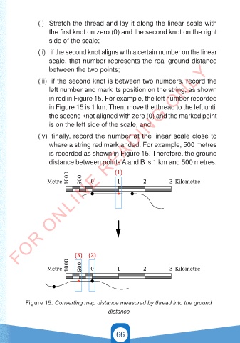
(i)  Stretch the thread and lay it along the linear scale with
                     the first knot on zero (0) and the second knot on the right
                     side of the scale;

                 (ii)   if the second knot aligns with a certain number on the linear
                     scale, that number represents the real ground distance
        FOR ONLINE READING ONLY
                     between the two points;

                 (iii)  if the second knot is between two numbers, record the
                     left number and mark its position on the string, as shown
                     in red in Figure 15. For example, the left number recorded
                     in Figure 15 is 1 km. Then, move the thread to the left until

                     the second knot aligned with zero (0) and the marked point
                     is on the left side of the scale; and

                 (iv)  finally, record the number at the linear scale close to
                     where a string red mark anded. For example, 500 metres
                     is recorded as shown in Figure 15. Therefore, the ground

                     distance between points A and B is 1 km and 500 metres.

                             1000                (1)
                     Metre         500  0         1          2         3 Kilometre


                                (3) (2)
                             1000  500
                     Metre             0          1          2         3 Kilometre


            Figure 15: Converting map distance measured by thread into the ground
                                              distance


                                                 66
         GSPublisherVersion 0.5.100.100

                                                                                          21/11/2024   16:58
   GEOGRAPHY AND THE ENVIRONMENT-STD 4.indd   66
   GEOGRAPHY AND THE ENVIRONMENT-STD 4.indd   66                                          21/11/2024   16:58