
Page 70 - Geography_n_Environment
P. 70
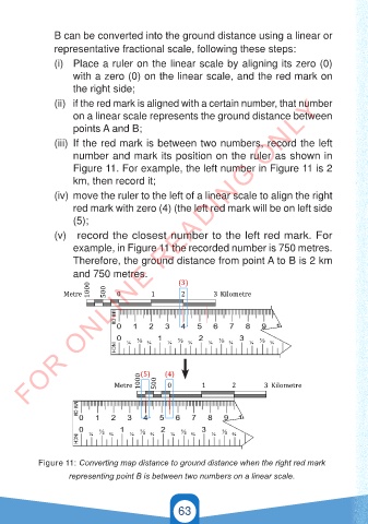
B can be converted into the ground distance using a linear or
                representative fractional scale, following these steps:

                (i)  Place a ruler on the linear scale by aligning its zero (0)
                     with a zero (0) on the linear scale, and the red mark on
                     the right side;
        FOR ONLINE READING ONLY
                (ii)  if the red mark is aligned with a certain number, that number
                     on a linear scale represents the ground distance between
                     points A and B;

                (iii)  If the red mark is between two numbers, record the left
                     number and mark its position on the ruler as shown in
                     Figure 11. For example, the left number in Figure 11 is 2
                     km, then record it;

                (iv)  move the ruler to the left of a linear scale to align the right
                     red mark with zero (4) (the left red mark will be on left side
                     (5);
                (v)   record the closest number to the left red mark. For

                     example, in Figure 11 the recorded number is 750 metres.
                                                 (3)
                  Metre  1000  500  0     1       2        3 Kilometre
                     Therefore, the ground distance from point A to B is 2 km
                     and 750 metres.

                         1000                    (3)
                  Metre       500  0      1       2        3 Kilometre


                                       1000  (5)  (4)
                                Metre      500  0       1       2        3 Kilometre


                                       1000  (5)  500  (4)
                                Metre         0         1       2        3 Kilometre


           Figure 11: Converting map distance to ground distance when the right red mark

                    representing point B is between two numbers on a linear scale.
              GSPublisherVersion 0.5.100.100


                                                 63
              GSPublisherVersion 0.5.100.100


                                                                                          21/11/2024   16:58
   GEOGRAPHY AND THE ENVIRONMENT-STD 4.indd   63
   GEOGRAPHY AND THE ENVIRONMENT-STD 4.indd   63                                          21/11/2024   16:58