
Page 66 - Geography_n_Environment
P. 66
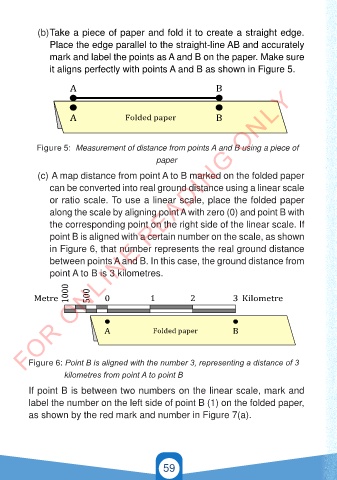
(b) Take a piece of paper and fold it to create a straight edge.
                Place the edge parallel to the straight-line AB and accurately
                mark and label the points as A and B on the paper. Make sure

                it aligns perfectly with points A and B as shown in Figure 5.

        FOR ONLINE READING ONLY
                      A                                          B


                      A               Folded paper               B


            Figure 5:  Measurement of distance from points A and B using a piece of
                                               paper

            (c)  A map distance from point A to B marked on the folded paper
                can be converted into real ground distance using a linear scale

                or ratio scale. To use a linear scale, place the folded paper
                along the scale by aligning point A with zero (0) and point B with
                the corresponding point on the right side of the linear scale. If
                point B is aligned with a certain number on the scale, as shown

                in Figure 6, that number represents the real ground distance
                        A
                                                                   B
                between points A and B. In this case, the ground distance from
                point A to B is 3 kilometres.
                        A            Karatasi iliyokunjwa          B
                     1000   500
           Metre                0            1           2            3 Kilometre


                                A             Folded paper            B


          Figure 6: Point B is aligned with the number 3, representing a distance of 3
 GSPublisherVersion 0.6.100.100
                      kilometres from point A to point B
          If point B is between two numbers on the linear scale, mark and
          label the number on the left side of point B (1) on the folded paper,
          as shown by the red mark and number in Figure 7(a).


                    1000

           Meta           500  0            1           2            3 Kilometa

                                                 59

                               A         Karatasi iliyokunjwa        B
                                                                                          21/11/2024   16:58
   GEOGRAPHY AND THE ENVIRONMENT-STD 4.indd   59
   GEOGRAPHY AND THE ENVIRONMENT-STD 4.indd   59                                          21/11/2024   16:58


  GSPublisherVersion 0.6.100.100