
Page 67 - Geography_n_Environment
P. 67
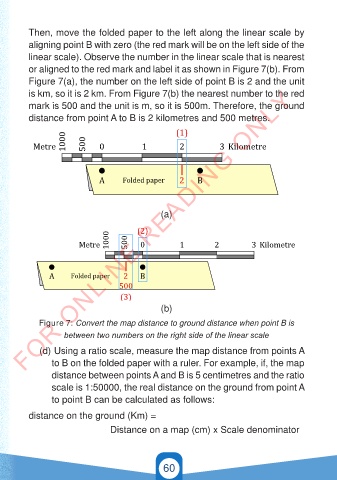
Then, move the folded paper to the left along the linear scale by
          aligning point B with zero (the red mark will be on the left side of the
          linear scale). Observe the number in the linear scale that is nearest

          or aligned to the red mark and label it as shown in Figure 7(b). From
          Figure 7(a), the number on the left side of point B is 2 and the unit
        FOR ONLINE READING ONLY
          is km, so it is 2 km. From Figure 7(b) the nearest number to the red
          mark is 500 and the unit is m, so it is 500m. Therefore, the ground
          distance from point A to B is 2 kilometres and 500 metres.
                                                (1)
                  1000                               (1)
         Metre         500  0          1         2          3 Kilometre
           Metre    1000  500  0           1          2           3 Kilometre


                           A      Folded paper   2    B

                              A      Folded paper     2    B


                                                 (a)


                                 1000     (2)
                        Metre        1000 500  0  (2)  1         2          3 Kilometre

                           Metre           500  0           1          2           3 Kilometre
                A     Folded paper    2    B
                                    500
                  A      Folded paper (3)  2   B
                                        500      (b)
                                         (3)
             Figure 7: Convert the map distance to ground distance when point B is
                    between two numbers on the right side of the linear scale

             (d)  Using a ratio scale, measure the map distance from points A
      GSPublisherVersion 0.6.100.100
                to B on the folded paper with a ruler. For example, if, the map
                distance between points A and B is 5 centimetres and the ratio
                scale is 1:50000, the real distance on the ground from point A
       GSPublisherVersion 0.6.100.100
                to point B can be calculated as follows:


          distance on the ground (Km) =
                                         Distance on a map (cm) x Scale denominator


                                                 60


                                                                                          21/11/2024   16:58
   GEOGRAPHY AND THE ENVIRONMENT-STD 4.indd   60
   GEOGRAPHY AND THE ENVIRONMENT-STD 4.indd   60                                          21/11/2024   16:58