
Page 72 - Geography_n_Environment
P. 72
Measurement of curved distance
To measure the distance of curved features such as rivers, roads,
or railways, tools like a pair of dividers, a piece of paper, thread or
string, and scale are used.
FOR ONLINE READING ONLY
1. Using thread / string
The following steps are involved to determine a curved distance on
a map using a string:
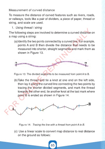
(a) Identify the two points connected by a curved line. For example,
points A and B then divede the distance that needs to be
measured into shorter, straight segments and mark them as
shown in Figure 13.
Figure 13: The divided segments to be measured from point A to B.
(b) Take the thread and tie a knot at one end on the left side,
then lay it along the curved line connecting the two points by
tracing the shorter divided segments, and mark the thread
towards the other end, tie another knot at the last mark where
point B is ended as shown in Figure 14.
Figure 14: Tracing the line with a thread from point A to B.
(c) Use a linear scale to convert map distance to real distance
on the ground as follows:
65
21/11/2024 16:58
GEOGRAPHY AND THE ENVIRONMENT-STD 4.indd 65 21/11/2024 16:58
GEOGRAPHY AND THE ENVIRONMENT-STD 4.indd 65